Roadworks notification from National Highways
We’re writing to inform you of some upcoming essential resurfacing work on the A49 at Bayston Hill. Our work has been combined to minimise future disruption and to provide a smoother and safer road surface for users.
- Resurfacing of the A49
- Resurfacing of the laybys within our working area
- Renewal of high friction surfacing
- Refresh all road markings throughout our working area
- Road studs to be re-instated
- Replacement of 4 signs
- Renewal of ironworks and drainage gully repairs
- Removal of debris
Safety is and always will be our number one priority; that is why our ambition remains that no one should be harmed while travelling or working on our roads.
When will this work take place?
We’ll work overnight from Monday 2 February 2026 to April 2026, between 8pm and 6am, Monday to Friday, ending 6am Saturday mornings.
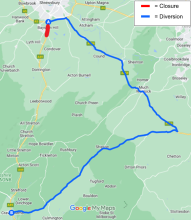
To carry out our work safely, we’ll work under a full closure of the A49 from Bayston Hill roundabout to the junction at Station Road in Condover.
During closures, the following diversion route will be in place for strategic traffic. Local access will be maintained between Craven Arms and Condover.
A49 Bayston Hill to Craven Arms